


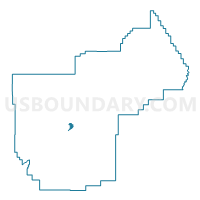
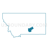
Precinct 46H, Yellowstone County, Montana
About
Outline

Summary
| Unique Area Identifier | 612358 |
| Name | Precinct 46H |
| County | Yellowstone County |
| State | Montana |
| Area (square miles) | 2.05 |
| Land Area (square miles) | 1.82 |
| Water Area (square miles) | 0.23 |
| % of Land Area | 88.71 |
| % of Water Area | 11.29 |
| Latitude of the Internal Point | 45.83389260 |
| Longtitude of the Internal Point | -108.43747900 |
Maps

Graphs
Select a template below for downloading or customizing gragh for Precinct 46H, Yellowstone County, Montana


Neighbors
Neighoring Voting District (by Name) Neighboring Voting District on the Map
- Precinct 44B, Yellowstone County, MT
- Precinct 46B, Yellowstone County, MT
- Precinct 46C, Yellowstone County, MT
- Precinct 48A, Yellowstone County, MT
- Precinct 48B, Yellowstone County, MT
Top 10 Neighboring County Subdivision (by Population) Neighboring County Subdivision on the Map
Top 10 Neighboring Place (by Population) Neighboring Place on the Map
Top 10 Neighboring Elementary School District (by Population) Neighboring Elementary School District on the Map
- Billings Elementary School District, MT (107,977)
- Lockwood Elementary School District, MT (7,865)
- Independent Elementary School District, MT (2,624)
- Pioneer Elementary School District, MT (913)
Top 10 Neighboring Secondary School District (by Population) Neighboring Secondary School District on the Map
Top 10 Neighboring State Legislative District Lower Chamber (by Population) Neighboring State Legislative District Lower Chamber on the Map
- State House District 46, MT (13,942)
- State House District 48, MT (10,702)
- State House District 44, MT (9,744)
Top 10 Neighboring State Legislative District Upper Chamber (by Population) Neighboring State Legislative District Upper Chamber on the Map
- State Senate District 23, MT (23,380)
- State Senate District 24, MT (21,679)
- State Senate District 22, MT (19,347)
Top 10 Neighboring 111th Congressional District (by Population) Neighboring 111th Congressional District on the Map
Top 10 Neighboring Census Tract (by Population) Neighboring Census Tract on the Map
- Census Tract 7.02, Yellowstone County, MT (7,400)
- Census Tract 15.01, Yellowstone County, MT (4,540)
- Census Tract 8, Yellowstone County, MT (4,461)
- Census Tract 7.06, Yellowstone County, MT (4,178)